-

- Yasushi Kitazawa Museum
- 1F ニッポン観光ペナント展示館
- 美し森 お土産ペナント 1960年代 20250317


美し森 お土産ペナント 1960年代 20250317
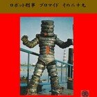
「美し森」(うつくしもり、山梨県)
北杜市(ホクト-)、清里高原の観光地。駐車場から頂上までは徒歩15分ほどの展望台。八ヶ岳の主峰・赤岳の尾根にある頂のひとつで、ペナントには標高1548mとあるが現在は1542mとされている。
これは八ヶ岳と高原の景色を描く作品。天女山の看板も登場しているので、美し森~天女山の登山コース込みといったところだろうか。リンドウ(?)の花が可愛らしい。全長68.5cm。
[1960~70年代/ #昭和100年 ]
【画像の説明】
1, 美し森のペナント。黒い布にイラストをプリント。ペナントの左に黄色い編み紐、2本付き。
2, イラストは八ヶ岳連峰の山並みと高原の景色。
3, イラストの拡大。険しい稜線が連なる八ヶ岳を背景に高原が広がっている。手前に紫色のリンドウの花が咲き乱れている。なお、"天女山 1528m"の看板が描かれている。天女山は美し森から登山道で往復4時間ほどの距離にあり、雄大な景色が広がる人気のハイキングコースである。
4, タイトルは和文。ゴシック体の漢字で "美し森" (赤)。サブタイトルも同じく "清里高原" 。ペナントの右端に標高 "1548M" が記されている (赤)。
-----------------------------------------------------
Souvenir #pennant in Japan, my collection.
"美し森" Mt. Utsukushimori, Yamanashi Prefecture.
Mt. Utsukushimori is a 1,548-meter-high ※ (5078 ft) mountain located on the Kiyosato highlands. It is a popular tourist destination and a wonderful vantage point from which to view the Yatsugatake mountain range and the highlands.
Length 68.5cm (26.9in). This pennant was produced around the 1960s or 1970s. #vintage
※ It is currently corrected to 1542 meters (5059 ft).
【Images description】
1, A pennant of a Mt. Utsukushimori. It is a black cloth with an illustration printed on it and two yellow braided strings attached to the left of the pennant.
2, The illustration is a view of the Yatsugatake mountain range and highlands.
3, Enlarged image of the illustration. The highland spreads out against the background of the Yatsugatake mountain range with its steep ridges. In the foreground, purple gentian flowers are in full bloom. In addition, a signboard reading "Mt. Tennyo, 1528m" is drawn. Mt. Tennyo is a popular hiking course, about a four-hour round trip by trail from Mt. Utsukushimori.
4, The title is in Japanese. The title is "Utsukushimori" (red) in Kanji characters. The subtitle is also "Kiyosato highlands". The elevation "1548M" is written on the right side of the pennant (red).